ھۆججەت:Campaign of the Battle of Ain Jalut 1260.svg

Size of this PNG preview of this SVG file: 432 × 572 پىكسېل. باشقا چوڭلۇقى: 181 × 240 پىكسېل | 362 × 480 پىكسېل | 580 × 768 پىكسېل | 773 × 1,024 پىكسېل | 1,547 × 2,048 پىكسېل.
ئەسلى ھۆججەت (SVG ھۆججىتى، ئاتاقتىكى چوڭلۇقى 432 × 572 نۇقتا، ھۆججەت چوڭلۇقى: 146 KB)
ئۈزۈندە
| چۈشەندۈرۈش |
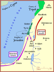
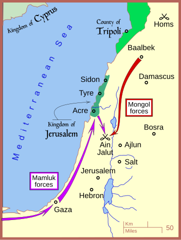
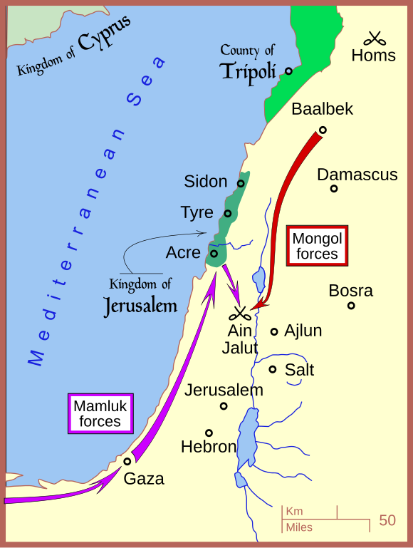
English: A map of the campaign leading to the Battle of Ain Jalut — in 1260 CE. |
| چېسلا | |
| مەنبە | ئۆز ئەسىرىم |
| يازغۇچى | MapMaster |
| Other versions |
[]
|


|
This SVG file contains embedded text that can be translated into your language, using any capable SVG editor, text editor or the SVG Translate tool. For more information see: About translating SVG files. |
References
- Amitai-Preiss, Reuven (1995) Mongols and Mamluks: The Mamluk-Ilkhanid War, 1260-1281, Cambridge University Press, Cambridge ISBN: 978-0521462266.
- Tschanz, David W. (July/August 2007). "History's Hinge: 'Ain Jalut". Saudi Aramco World. Retrieved on 2007-09-24.
The borders of the rump Kingdom of Jerusalem and the County of Tripoli are based on:
- Sheperd, William R. (1911) "Mediterranean Lands after 1204", in Historical Atlas, New York: Henry Holt and Company, p. 73.
ئىجازەت
I, the copyright holder of this work, hereby publish it under the following license:
This file is licensed under the Creative Commons Attribution 3.0 Unported license.
- سىز ئەركىن:
- بەھىرلەش – to copy, distribute and transmit the work
- ئۆزگەرتىش – ئىجادىي ئەسەر
- تۆۋەندىكى شەرتلەرگە چوقۇم ئەمەل قىلىڭ:
- ئىمزا – You must give appropriate credit, provide a link to the license, and indicate if changes were made. You may do so in any reasonable manner, but not in any way that suggests the licensor endorses you or your use.
ھۆججەت تارىخى
چېسلا/ۋاقىت چېكىلسە ئەينى ۋاقىتتا كۆرۈلگەن ھۆججەتنى كۆرسىتىدۇ.
| چېسلا/ۋاقىت | كىچىك سۈرەت | ئۆلچەم | ئىشلەتكۈچى | ئىزاھات | |
|---|---|---|---|---|---|
| نۆۋەتتىكى | 19:01, 7 ئىيۇل 2008 | | 432 × 572 (146 KB) | MapMaster | adjusting colors |
| 04:53, 18 ئىيۇن 2008 |  | 432 × 572 (151 KB) | MapMaster | ||
| 16:22, 13 ئىيۇن 2008 |  | 432 × 572 (146 KB) | MapMaster | minor edits | |
| 11:33, 13 ئىيۇن 2008 |  | 434 × 574 (126 KB) | MapMaster | {{Information |Description={{en|1=A map of the campaign leading to the Battle of Ain Jalut, 1260.}} |Source=Own work by uploader |Author=MapMaster |Date=13 June 2008 |Permission= |other_versions= }} {{ImageUpload|full}} |
ھۆججەت ئىشلىتىلىشى
تۆۋەندىكى بەت بۇ ھۆججەتنى ئىشلىتىدۇ:
ئورتاق ھۆججەت ئىشلىتىلىشى
تۆۋەندىكى باشقا ۋىكىلار بۇ ھۆججەتنى ئىشلىتىدۇ:
- azb.wikipedia.org دىكى ئىشلىتىشى
- ba.wikipedia.org دىكى ئىشلىتىشى
- bg.wikipedia.org دىكى ئىشلىتىشى
- bn.wikipedia.org دىكى ئىشلىتىشى
- ca.wikipedia.org دىكى ئىشلىتىشى
- ckb.wikipedia.org دىكى ئىشلىتىشى
- cs.wikipedia.org دىكى ئىشلىتىشى
- de.wikipedia.org دىكى ئىشلىتىشى
- en.wikipedia.org دىكى ئىشلىتىشى
- es.wikipedia.org دىكى ئىشلىتىشى
- et.wikipedia.org دىكى ئىشلىتىشى
- fr.wikipedia.org دىكى ئىشلىتىشى
- he.wikipedia.org دىكى ئىشلىتىشى
- hr.wikipedia.org دىكى ئىشلىتىشى
- id.wikipedia.org دىكى ئىشلىتىشى
- ja.wikipedia.org دىكى ئىشلىتىشى
- ko.wikipedia.org دىكى ئىشلىتىشى
- lt.wikipedia.org دىكى ئىشلىتىشى
- ml.wikipedia.org دىكى ئىشلىتىشى
- nl.wikipedia.org دىكى ئىشلىتىشى
- no.wikipedia.org دىكى ئىشلىتىشى
- pl.wikipedia.org دىكى ئىشلىتىشى
- pnb.wikipedia.org دىكى ئىشلىتىشى
- ru.wikipedia.org دىكى ئىشلىتىشى
- sl.wikipedia.org دىكى ئىشلىتىشى
- so.wikipedia.org دىكى ئىشلىتىشى
- sr.wikipedia.org دىكى ئىشلىتىشى
- su.wikipedia.org دىكى ئىشلىتىشى
- sv.wikipedia.org دىكى ئىشلىتىشى
- th.wikipedia.org دىكى ئىشلىتىشى
- tr.wikipedia.org دىكى ئىشلىتىشى
- uk.wikipedia.org دىكى ئىشلىتىشى
- ur.wikipedia.org دىكى ئىشلىتىشى
- uz.wikipedia.org دىكى ئىشلىتىشى
- www.wikidata.org دىكى ئىشلىتىشى
- zh.wikipedia.org دىكى ئىشلىتىشى