ھۆججەت:Chunqiu map-zh-classical.png
يۇقىرىراق پەرق ئېتىش نىسبىتى يوق.
Chunqiu_map-zh-classical.png (430 × 550 پىكسېل، ھۆججەت چوڭلۇقى: 273 KB، MIME تىپى: image/png)

|
This map has been uploaded by Electionworld from en.wikipedia.org to enable the |
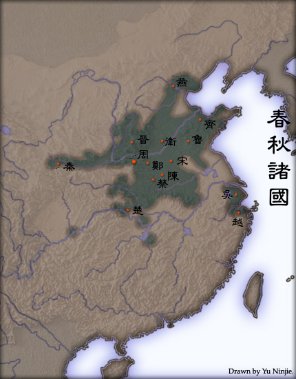
Extent of urbanisation in Spring and Autumn Period China. Based on "The spread of cities in China during the Spring and Autumns period" in Cultural Atlas of China. The first capital city of selected states are marked.
Created and copyright (2004) by Yu Ninjie. Released under the GNU FDL.
The originally picture is located at Image:Chunqiu map.jpg.
The Classical Chinese Modification is made by User:Itsmine.
Yeu Ninje from en.wikipedia.org, the copyright holder of this work, hereby publishes it under the following license:

|
Permission is granted to copy, distribute and/or modify this document under the terms of the GNU Free Documentation License, Version 1.2 or any later version published by the Free Software Foundation; with no Invariant Sections, no Front-Cover Texts, and no Back-Cover Texts. A copy of the license is included in the section entitled GNU Free Documentation License. |
| This file is licensed under the Creative Commons Attribution-Share Alike 3.0 Unported license. | ||
| ئىمزا: Yeu Ninje | ||
| ||
| This licensing tag was added to this file as part of the GFDL licensing update. |
ھۆججەت تارىخى
چېسلا/ۋاقىت چېكىلسە ئەينى ۋاقىتتا كۆرۈلگەن ھۆججەتنى كۆرسىتىدۇ.
| چېسلا/ۋاقىت | كىچىك سۈرەت | ئۆلچەم | ئىشلەتكۈچى | ئىزاھات | |
|---|---|---|---|---|---|
| نۆۋەتتىكى | 07:35, 16 ئاپرېل 2007 | | 430 × 550 (273 KB) | Itsmine | {{ew|en|Yeu Ninje}} Extent of {{link|urbanisation}} in {{link|Spring and Autumn Period}} China. Based on "The spread of cities in China during the Spring and Autumns period" in ''Cultural Atlas of China''. The first capital city of selected states are mar |
ھۆججەت ئىشلىتىلىشى
تۆۋەندىكى بەت بۇ ھۆججەتنى ئىشلىتىدۇ:
ئورتاق ھۆججەت ئىشلىتىلىشى
تۆۋەندىكى باشقا ۋىكىلار بۇ ھۆججەتنى ئىشلىتىدۇ:
- fr.wikipedia.org دىكى ئىشلىتىشى
- ja.wikipedia.org دىكى ئىشلىتىشى
- ko.wikipedia.org دىكى ئىشلىتىشى
- zh-classical.wikipedia.org دىكى ئىشلىتىشى
- zh-yue.wikipedia.org دىكى ئىشلىتىشى
- zh.wikipedia.org دىكى ئىشلىتىشى
- 周朝
- User:Keasung
- User:Jungleford
- User:Hankensai
- Template:User 春秋
- User:Duzhe
- User:Yew
- User:衖追命/巴別
- Wikipedia:用户框/历史
- User:Unphoenix
- User:Dnssgh/用户框
- User:Dbslikacheung/用戶框
- User:HB~zhwiki/我的用戶框
- User:星光下的人
- User:Cloudwat
- User:Jason22/info
- User:Tonyshew
- User:凱子書生
- User talk:Sinji
- User:Pino100
- User:Edwardtp/info
- User:B0924
- User:Vphoenix
- User:立足东方
- User:熙熙攘攘熙熙
- User:Dora168
- User:Chakhar
- User:Choipo
- User:Gzhao
- User:黑色騎士團員
- User:Show04191
- User:Polar1/info
- User:Life Stream
- User:願聞其祥
View more global usage of this file.