ھۆججەت:Cities of Sumer (en).svg

Size of this PNG preview of this SVG file: 436 × 480 پىكسېل. باشقا چوڭلۇقى: 218 × 240 پىكسېل | 698 × 768 پىكسېل | 930 × 1,024 پىكسېل | 1,860 × 2,048 پىكسېل.
ئەسلى ھۆججەت (SVG ھۆججىتى، ئاتاقتىكى چوڭلۇقى 436 × 480 نۇقتا، ھۆججەت چوڭلۇقى: 67 KB)
| چۈشەندۈرۈش |
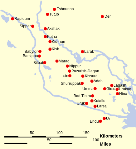
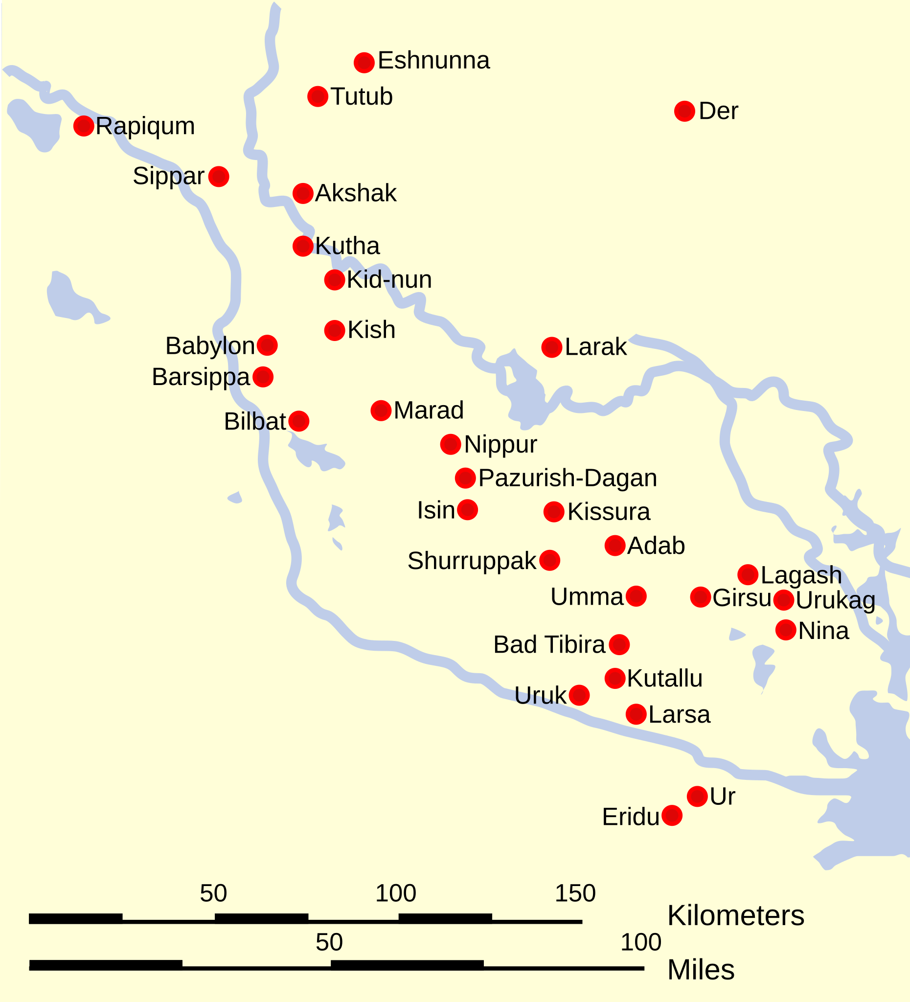
English: Map with the locations of the main cities of Sumer and Elam. |
| چېسلا | (UTC) |
| مەنبە | |
| يازغۇچى |
|
| Other versions |
[]
|

.svg)

.svg)
.svg)

.svg)


.svg)

.svg)
.svg)
| This is a retouched picture, which means that it has been digitally altered from its original version. Modifications: Translation to English. The original can be viewed here: Ciudades de Sumeria.svg:
|
I, the copyright holder of this work, hereby publish it under the following licenses:
This file is licensed under the Creative Commons Attribution 3.0 Unported license.
- سىز ئەركىن:
- بەھىرلەش – to copy, distribute and transmit the work
- ئۆزگەرتىش – ئىجادىي ئەسەر
- تۆۋەندىكى شەرتلەرگە چوقۇم ئەمەل قىلىڭ:
- ئىمزا – You must give appropriate credit, provide a link to the license, and indicate if changes were made. You may do so in any reasonable manner, but not in any way that suggests the licensor endorses you or your use.

|
Permission is granted to copy, distribute and/or modify this document under the terms of the GNU Free Documentation License, Version 1.2 or any later version published by the Free Software Foundation; with no Invariant Sections, no Front-Cover Texts, and no Back-Cover Texts. A copy of the license is included in the section entitled GNU Free Documentation License. |
You may select the license of your choice.
Original upload log
This image is a derivative work of the following images:
- File:Ciudades_de_Sumeria.svg licensed with Cc-by-3.0, GFDL
- 2011-02-09T16:25:44Z Phirosiberia 436x480 (60556 Bytes) Translation
- 2011-02-09T16:19:12Z Phirosiberia 436x480 (60496 Bytes) Scale added
- 2009-01-18T20:30:44Z Phirosiberia 436x480 (63461 Bytes) {{Information |Description= |Source= |Date= |Author= |Permission= |other_versions= }}
- 2009-01-18T20:29:17Z Phirosiberia 436x480 (68605 Bytes) {{Information |Description= |Source= |Date= |Author= |Permission= |other_versions= }}
- 2008-02-12T15:54:29Z Phirosiberia 436x480 (63094 Bytes) == Sumario == {{Information |Description={{es|Mapa de la localización de las principales ciudades de Sumeria y Elam}} |Source=self-made |Date=2008-01-21 |Author= [[User:Crates|Crates]] |Permission=PD-self |other_versions= }}
- 2008-02-01T13:25:19Z Phirosiberia 442x482 (63107 Bytes) {{Information |Description={{es|Mapa de la localización de las principales ciudades de Sumeria y Elam}} |Source=self-made |Date=2008-01-21 |Author= [[User:Crates|Crates]] |Permission=PD-self |other_versions= }} [[Category:S
- 2008-02-01T13:12:38Z Phirosiberia 440x480 (85360 Bytes) {{Information |Description={{es|Mapa de la localización de las principales ciudades de Sumeria}} |Source=self-made |Date=2008-01-21 |Author= [[User:Crates|Crates]] |Permission=PD-self |other_versions= }} [[Category:Sumer]]
- 2008-01-31T19:19:24Z Phirosiberia 810x530 (85340 Bytes) {{Information |Description={{es|Mapa de la localización de las principales ciudades de Sumeria y Elam}} |Source=self-made |Date=2008-01-21 |Author= [[User:Crates|Crates]] |Permission=PD-self |other_versions= }} [[Category:S
Uploaded with derivativeFX
ھۆججەت تارىخى
چېسلا/ۋاقىت چېكىلسە ئەينى ۋاقىتتا كۆرۈلگەن ھۆججەتنى كۆرسىتىدۇ.
| چېسلا/ۋاقىت | كىچىك سۈرەت | ئۆلچەم | ئىشلەتكۈچى | ئىزاھات | |
|---|---|---|---|---|---|
| نۆۋەتتىكى | 01:16, 20 فېۋرال 2013 | | 436 × 480 (67 KB) | Lexicon | Further touchup. |
| 01:06, 20 فېۋرال 2013 |  | 436 × 480 (62 KB) | Lexicon | Minor clean-up for clarity, remove unlabelled dot. | |
| 16:28, 9 فېۋرال 2011 |  | 436 × 480 (59 KB) | Phirosiberia | {{Information |Description={{en|Map with the locations of the main cities of Sumer and Elam.}} |Source=*File:Ciudades_de_Sumeria.svg |Date=2011-02-09 16:28 (UTC) |Author=*File:Ciudades_de_Sumeria.svg: Crates *derivative work: ~ |
ھۆججەت ئىشلىتىلىشى
ئورتاق ھۆججەت ئىشلىتىلىشى
تۆۋەندىكى باشقا ۋىكىلار بۇ ھۆججەتنى ئىشلىتىدۇ:
- ar.wikipedia.org دىكى ئىشلىتىشى
- bn.wikipedia.org دىكى ئىشلىتىشى
- br.wikipedia.org دىكى ئىشلىتىشى
- bs.wikipedia.org دىكى ئىشلىتىشى
- ckb.wikipedia.org دىكى ئىشلىتىشى
- cs.wikipedia.org دىكى ئىشلىتىشى
- en.wikipedia.org دىكى ئىشلىتىشى
- en.wikibooks.org دىكى ئىشلىتىشى
- et.wikipedia.org دىكى ئىشلىتىشى
- fa.wikipedia.org دىكى ئىشلىتىشى
- fr.wikipedia.org دىكى ئىشلىتىشى
- he.wikipedia.org دىكى ئىشلىتىشى
- hi.wikipedia.org دىكى ئىشلىتىشى
- id.wikipedia.org دىكى ئىشلىتىشى
- id.wikibooks.org دىكى ئىشلىتىشى
- it.wikipedia.org دىكى ئىشلىتىشى
- ko.wikipedia.org دىكى ئىشلىتىشى
- ku.wikipedia.org دىكى ئىشلىتىشى
- la.wikipedia.org دىكى ئىشلىتىشى
- lt.wikipedia.org دىكى ئىشلىتىشى
View more global usage of this file.
.svg)
.svg)