ھۆججەت:French Polynesia relief map.svg

Size of this PNG preview of this SVG file: 600 × 600 پىكسېل. باشقا چوڭلۇقى: 240 × 240 پىكسېل | 480 × 480 پىكسېل | 768 × 768 پىكسېل | 1,024 × 1,024 پىكسېل | 2,048 × 2,048 پىكسېل | 1,260 × 1,260 پىكسېل.
ئەسلى ھۆججەت (SVG ھۆججىتى، ئاتاقتىكى چوڭلۇقى 1,260 × 1,260 نۇقتا، ھۆججەت چوڭلۇقى: 1.4 MB)
ئۈزۈندە
| چۈشەندۈرۈش |
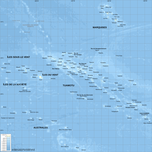
English: Topographic map with French names of French Polynesia
Français : Carte topographique de la Polynésie française, en français |
| چېسلا | |
| مەنبە |
Own work.
Data sources :
Softwares used :
Others :
|
| يازغۇچى | L. Claudel (Sardon - fr:Sardon) |
| Other versions |
[]
|


|
This SVG file contains embedded text that can be translated into your language, using any capable SVG editor, text editor or the SVG Translate tool. For more information see: About translating SVG files. |
This W3C-unspecified vector image was created with Inkscape .
ئىجازەت
I, the copyright holder of this work, hereby publish it under the following licenses:

|
Permission is granted to copy, distribute and/or modify this document under the terms of the GNU Free Documentation License, Version 1.2 or any later version published by the Free Software Foundation; with no Invariant Sections, no Front-Cover Texts, and no Back-Cover Texts. A copy of the license is included in the section entitled GNU Free Documentation License. |
This file is licensed under the Creative Commons Attribution-Share Alike 3.0 Unported, 2.5 Generic, 2.0 Generic and 1.0 Generic license.
- سىز ئەركىن:
- بەھىرلەش – to copy, distribute and transmit the work
- ئۆزگەرتىش – ئىجادىي ئەسەر
- تۆۋەندىكى شەرتلەرگە چوقۇم ئەمەل قىلىڭ:
- ئىمزا – You must give appropriate credit, provide a link to the license, and indicate if changes were made. You may do so in any reasonable manner, but not in any way that suggests the licensor endorses you or your use.
- ئوخشاش ئۇسۇلدا بەھىرلەش – If you remix, transform, or build upon the material, you must distribute your contributions under the same or compatible license as the original.
You may select the license of your choice.
ھۆججەت تارىخى
چېسلا/ۋاقىت چېكىلسە ئەينى ۋاقىتتا كۆرۈلگەن ھۆججەتنى كۆرسىتىدۇ.
| چېسلا/ۋاقىت | كىچىك سۈرەت | ئۆلچەم | ئىشلەتكۈچى | ئىزاھات | |
|---|---|---|---|---|---|
| نۆۋەتتىكى | 20:29, 16 ئۆكتەبىر 2008 | | 1,260 × 1,260 (1.4 MB) | Sardon | {{Information |Description={{en|1=Topographic map with French names of French Polynesia}} {{fr|1=Carte topographique de la Polynésie française, en français}} |Source=Own work.{{clr}} Data sources : * Background map : [http://www.ngdc.noaa.gov/mgg/globa |
ھۆججەت ئىشلىتىلىشى
تۆۋەندىكى بەت بۇ ھۆججەتنى ئىشلىتىدۇ:
ئورتاق ھۆججەت ئىشلىتىلىشى
تۆۋەندىكى باشقا ۋىكىلار بۇ ھۆججەتنى ئىشلىتىدۇ:
- ace.wikipedia.org دىكى ئىشلىتىشى
- bn.wikipedia.org دىكى ئىشلىتىشى
- ckb.wikipedia.org دىكى ئىشلىتىشى
- cs.wikipedia.org دىكى ئىشلىتىشى
- de.wikipedia.org دىكى ئىشلىتىشى
- en.wikipedia.org دىكى ئىشلىتىشى
- en.wikibooks.org دىكى ئىشلىتىشى
- eo.wikipedia.org دىكى ئىشلىتىشى
- es.wikipedia.org دىكى ئىشلىتىشى
- et.wikipedia.org دىكى ئىشلىتىشى
- fi.wikipedia.org دىكى ئىشلىتىشى
- fr.wikipedia.org دىكى ئىشلىتىشى
- Polynésie française
- Liste des colonies françaises
- Utilisateur:Sardon
- Wikipédia:Atelier graphique/Cartes/Archives/octobre 2008
- Wikipédia:Atelier graphique/Cartes/Archives/novembre 2009
- Utilisateur:NanouchkaZen
- 2011 par pays en Océanie
- Wikipédia:Atelier graphique/Cartes/Archives/août 2015
- Wikipédia:Atelier graphique/Cartes/Archives/décembre 2015
- Wikipédia:Atelier graphique/Cartes/Archives/janvier 2016
- Utilisateur:Exp JC/Brouillon
- 2010 en Polynésie française
- fr.wiktionary.org دىكى ئىشلىتىشى
- gcr.wikipedia.org دىكى ئىشلىتىشى
- gl.wikipedia.org دىكى ئىشلىتىشى
- hu.wikipedia.org دىكى ئىشلىتىشى
- id.wikipedia.org دىكى ئىشلىتىشى
- ka.wikipedia.org دىكى ئىشلىتىشى
- ko.wikipedia.org دىكى ئىشلىتىشى
- ml.wikipedia.org دىكى ئىشلىتىشى
- oc.wikipedia.org دىكى ئىشلىتىشى
- pl.wikipedia.org دىكى ئىشلىتىشى
- pt.wikipedia.org دىكى ئىشلىتىشى
- sq.wikipedia.org دىكى ئىشلىتىشى
- to.wikipedia.org دىكى ئىشلىتىشى
- tr.wiktionary.org دىكى ئىشلىتىشى
- tt.wikipedia.org دىكى ئىشلىتىشى
- vi.wikipedia.org دىكى ئىشلىتىشى
View more global usage of this file.