ھۆججەت:Indonesia provinces english.png

بۇ ئالدىن كۆزىتىشنىڭ چوڭلۇقى: 800 × 365 پىكسېل. باشقا چوڭلۇقى: 320 × 146 پىكسېل | 640 × 292 پىكسېل | 1,628 × 742 پىكسېل.
ئەسلى ھۆججەت (1,628 × 742 پىكسېل، ھۆججەت چوڭلۇقى: 92 KB، MIME تىپى: image/png)

|
File:Indonesia, administrative divisions - en - monochrome.svg is a vector version of this file. It should be used in place of this PNG file when not inferior.
File:Indonesia provinces english.png → File:Indonesia, administrative divisions - en - monochrome.svg
For more information, see Help:SVG. |
 |

|
This file requires updating because: In 2022, the Papua provinces changed from 2 provinces to 6 provinces. In doing so, you could add a timestamp to the file.
|
ئۈزۈندە
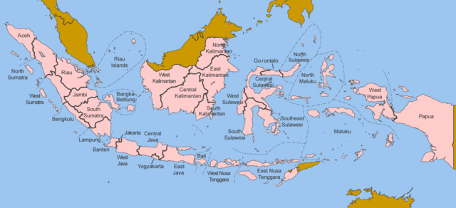
Map of the provinces of Indonesia in English.
Made by User:Golbez based on a PD CIA map, using other sources to guesstimate the extent of West Irian Jaya and West Sulawesi.
derivative works
Derivative works of this file: Indonesia, administrative divisions - en - monochrome.svg
ئىجازەت
I, the copyright holder of this work, hereby publish it under the following licenses:

|
Permission is granted to copy, distribute and/or modify this document under the terms of the GNU Free Documentation License, Version 1.2 or any later version published by the Free Software Foundation; with no Invariant Sections, no Front-Cover Texts, and no Back-Cover Texts. A copy of the license is included in the section entitled GNU Free Documentation License. |
| This file is licensed under the Creative Commons Attribution-Share Alike 3.0 Unported license. | ||
| ||
| This licensing tag was added to this file as part of the GFDL licensing update. |
This file is licensed under the Creative Commons Attribution 2.5 Generic license.
- سىز ئەركىن:
- بەھىرلەش – to copy, distribute and transmit the work
- ئۆزگەرتىش – ئىجادىي ئەسەر
- تۆۋەندىكى شەرتلەرگە چوقۇم ئەمەل قىلىڭ:
- ئىمزا – You must give appropriate credit, provide a link to the license, and indicate if changes were made. You may do so in any reasonable manner, but not in any way that suggests the licensor endorses you or your use.
You may select the license of your choice.
ھۆججەت تارىخى
چېسلا/ۋاقىت چېكىلسە ئەينى ۋاقىتتا كۆرۈلگەن ھۆججەتنى كۆرسىتىدۇ.
| چېسلا/ۋاقىت | كىچىك سۈرەت | ئۆلچەم | ئىشلەتكۈچى | ئىزاھات | |
|---|---|---|---|---|---|
| نۆۋەتتىكى | 12:40, 25 ئۆكتەبىر 2020 | | 1,628 × 742 (92 KB) | Afrogindahood | Addition of North Kalimantan province |
| 07:54, 8 يانۋار 2006 | 1,500 × 590 (77 KB) | Golbez | Map of the provinces of Indonesian in English. Made by User:Golbez based on a PD CIA map, using other sources to guesstimate the extent of West Irian Jaya and West Sulawesi. Category:Maps of Indonesia |
ھۆججەت ئىشلىتىلىشى
تۆۋەندىكى بەت بۇ ھۆججەتنى ئىشلىتىدۇ:
ئورتاق ھۆججەت ئىشلىتىلىشى
تۆۋەندىكى باشقا ۋىكىلار بۇ ھۆججەتنى ئىشلىتىدۇ:
- arz.wikipedia.org دىكى ئىشلىتىشى
- ba.wikipedia.org دىكى ئىشلىتىشى
- be-tarask.wikipedia.org دىكى ئىشلىتىشى
- blk.wikipedia.org دىكى ئىشلىتىشى
- bxr.wikipedia.org دىكى ئىشلىتىشى
- ca.wikipedia.org دىكى ئىشلىتىشى
- ceb.wikipedia.org دىكى ئىشلىتىشى
- crh.wikipedia.org دىكى ئىشلىتىشى
- csb.wikipedia.org دىكى ئىشلىتىشى
- cs.wikipedia.org دىكى ئىشلىتىشى
- cy.wikipedia.org دىكى ئىشلىتىشى
- da.wikipedia.org دىكى ئىشلىتىشى
- diq.wikipedia.org دىكى ئىشلىتىشى
- dv.wikipedia.org دىكى ئىشلىتىشى
- en.wikipedia.org دىكى ئىشلىتىشى
- es.wikipedia.org دىكى ئىشلىتىشى
- fr.wikipedia.org دىكى ئىشلىتىشى
- gd.wikipedia.org دىكى ئىشلىتىشى
- gl.wikipedia.org دىكى ئىشلىتىشى
- ht.wikipedia.org دىكى ئىشلىتىشى
- hu.wikipedia.org دىكى ئىشلىتىشى
- incubator.wikimedia.org دىكى ئىشلىتىشى
- it.wikipedia.org دىكى ئىشلىتىشى
- ja.wikipedia.org دىكى ئىشلىتىشى
- kaa.wikipedia.org دىكى ئىشلىتىشى
- kk.wikipedia.org دىكى ئىشلىتىشى
- km.wikipedia.org دىكى ئىشلىتىشى
- kn.wikipedia.org دىكى ئىشلىتىشى
- kv.wikipedia.org دىكى ئىشلىتىشى
- kw.wikipedia.org دىكى ئىشلىتىشى
- lij.wikipedia.org دىكى ئىشلىتىشى
- lmo.wikipedia.org دىكى ئىشلىتىشى
- ln.wikipedia.org دىكى ئىشلىتىشى
- lt.wikipedia.org دىكى ئىشلىتىشى
- lv.wikipedia.org دىكى ئىشلىتىشى
- mg.wikipedia.org دىكى ئىشلىتىشى
- mhr.wikipedia.org دىكى ئىشلىتىشى
- ml.wikipedia.org دىكى ئىشلىتىشى
- mn.wikipedia.org دىكى ئىشلىتىشى
- my.wikipedia.org دىكى ئىشلىتىشى
- mzn.wikipedia.org دىكى ئىشلىتىشى
- new.wikipedia.org دىكى ئىشلىتىشى
- nl.wikipedia.org دىكى ئىشلىتىشى
- nn.wikipedia.org دىكى ئىشلىتىشى
- pag.wikipedia.org دىكى ئىشلىتىشى
- pam.wikipedia.org دىكى ئىشلىتىشى
- pap.wikipedia.org دىكى ئىشلىتىشى
- pms.wikipedia.org دىكى ئىشلىتىشى
View more global usage of this file.