ھۆججەت:Karte Mesopotamien.png

بۇ ئالدىن كۆزىتىشنىڭ چوڭلۇقى: 800 × 565 پىكسېل. باشقا چوڭلۇقى: 320 × 226 پىكسېل | 640 × 452 پىكسېل | 1,024 × 723 پىكسېل | 1,126 × 795 پىكسېل.
ئەسلى ھۆججەت (1,126 × 795 پىكسېل، ھۆججەت چوڭلۇقى: 957 KB، MIME تىپى: image/png)
ئۈزۈندە
| چۈشەندۈرۈش |
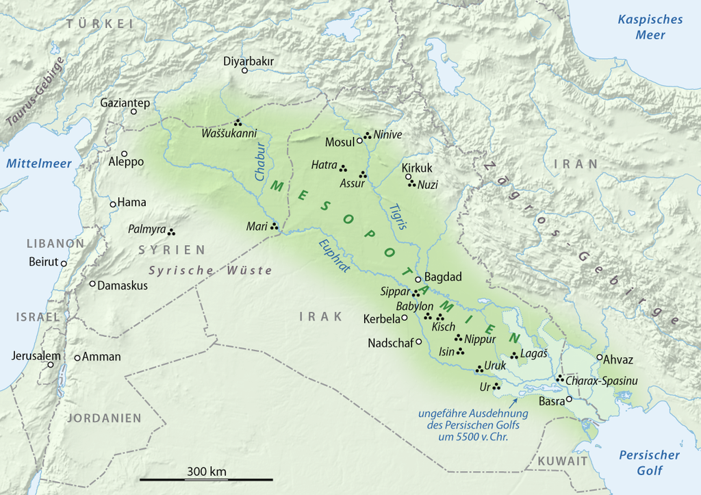
العربية: خريطة بلاد الرافدين
Deutsch: Karte von Mesopotamien
English: Map of Mesopotamia |
| چېسلا | 05.02.2008 |
| مەنبە |
Own work using: GTOPO-30 Elevation Data by USGS |
| يازغۇچى | NordNordWest |

|
File:N-Mesopotamia and Syria german.svg is a vector version of this file. It should be used in place of this PNG file when not inferior.
File:Karte Mesopotamien.png → File:N-Mesopotamia and Syria german.svg
For more information, see Help:SVG. |
 |

|
This map has been made or improved in the German Kartenwerkstatt (Map Lab). You can propose maps to improve as well.
|
ئىجازەت
I, the copyright holder of this work, hereby publish it under the following licenses:

|
Permission is granted to copy, distribute and/or modify this document under the terms of the GNU Free Documentation License, Version 1.2 or any later version published by the Free Software Foundation; with no Invariant Sections, no Front-Cover Texts, and no Back-Cover Texts. A copy of the license is included in the section entitled GNU Free Documentation License. |
This file is licensed under the Creative Commons Attribution 3.0 Unported license.
- سىز ئەركىن:
- بەھىرلەش – to copy, distribute and transmit the work
- ئۆزگەرتىش – ئىجادىي ئەسەر
- تۆۋەندىكى شەرتلەرگە چوقۇم ئەمەل قىلىڭ:
- ئىمزا – You must give appropriate credit, provide a link to the license, and indicate if changes were made. You may do so in any reasonable manner, but not in any way that suggests the licensor endorses you or your use.
You may select the license of your choice.
ھۆججەت تارىخى
چېسلا/ۋاقىت چېكىلسە ئەينى ۋاقىتتا كۆرۈلگەن ھۆججەتنى كۆرسىتىدۇ.
| چېسلا/ۋاقىت | كىچىك سۈرەت | ئۆلچەم | ئىشلەتكۈچى | ئىزاھات | |
|---|---|---|---|---|---|
| نۆۋەتتىكى | 19:51, 23 فېۋرال 2009 | | 1,126 × 795 (957 KB) | NordNordWest | corr |
| 16:54, 11 فېۋرال 2009 |  | 1,126 × 795 (1.1 MB) | NordNordWest | + antiker Küstenverlauf | |
| 09:17, 5 فېۋرال 2009 |  | 1,129 × 798 (1.22 MB) | NordNordWest | {{Information |Description= {{de|Karte von Mesopotamien}} {{en|Map of Mesopotamia}} |Source=self-made, using * GTOPO-30 Elevation Data by USGS |Date=05.02.2008 |Author=NordNordWest |Permissi |
ھۆججەت ئىشلىتىلىشى
تۆۋەندىكى بەت بۇ ھۆججەتنى ئىشلىتىدۇ:
ئورتاق ھۆججەت ئىشلىتىلىشى
تۆۋەندىكى باشقا ۋىكىلار بۇ ھۆججەتنى ئىشلىتىدۇ:
- als.wikipedia.org دىكى ئىشلىتىشى
- ar.wikipedia.org دىكى ئىشلىتىشى
- be-tarask.wikipedia.org دىكى ئىشلىتىشى
- be.wikipedia.org دىكى ئىشلىتىشى
- bg.wikipedia.org دىكى ئىشلىتىشى
- bxr.wikipedia.org دىكى ئىشلىتىشى
- ca.wikipedia.org دىكى ئىشلىتىشى
- ce.wikipedia.org دىكى ئىشلىتىشى
- cs.wikipedia.org دىكى ئىشلىتىشى
- cv.wikipedia.org دىكى ئىشلىتىشى
- da.wikipedia.org دىكى ئىشلىتىشى
- de.wikipedia.org دىكى ئىشلىتىشى
- en.wikipedia.org دىكى ئىشلىتىشى
- eo.wikipedia.org دىكى ئىشلىتىشى
- frr.wikipedia.org دىكى ئىشلىتىشى
- fr.wikipedia.org دىكى ئىشلىتىشى
- hsb.wikipedia.org دىكى ئىشلىتىشى
- hu.wikipedia.org دىكى ئىشلىتىشى
- ilo.wikipedia.org دىكى ئىشلىتىشى
- inh.wikipedia.org دىكى ئىشلىتىشى
- it.wikipedia.org دىكى ئىشلىتىشى
- it.wikibooks.org دىكى ئىشلىتىشى
- koi.wikipedia.org دىكى ئىشلىتىشى
- mr.wikipedia.org دىكى ئىشلىتىشى
- no.wikipedia.org دىكى ئىشلىتىشى
- pl.wikipedia.org دىكى ئىشلىتىشى
- pt.wikipedia.org دىكى ئىشلىتىشى
- ru.wikipedia.org دىكى ئىشلىتىشى
- sat.wikipedia.org دىكى ئىشلىتىشى
- sl.wikipedia.org دىكى ئىشلىتىشى
- so.wikipedia.org دىكى ئىشلىتىشى
View more global usage of this file.