ھۆججەت:LatinEmpire.png
بۇ ئالدىن كۆزىتىشنىڭ چوڭلۇقى: 800 × 396 پىكسېل. باشقا چوڭلۇقى: 320 × 158 پىكسېل | 640 × 316 پىكسېل | 1,024 × 506 پىكسېل | 1,715 × 848 پىكسېل.
ئەسلى ھۆججەت (1,715 × 848 پىكسېل، ھۆججەت چوڭلۇقى: 1.82 MB، MIME تىپى: image/png)
ئۈزۈندە
| چۈشەندۈرۈش |
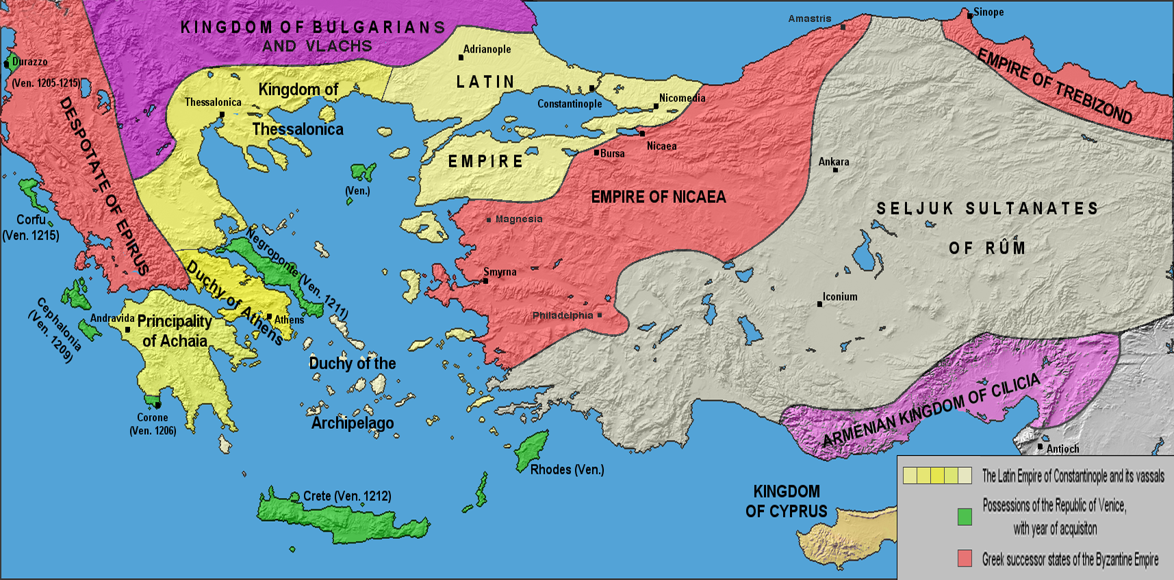
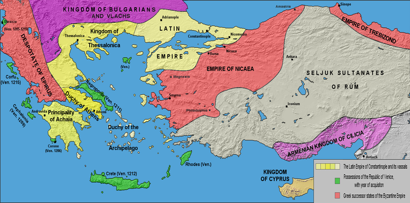
English: The borders of the Latin Empire and Byzantine Empire after the 4th crusade (1204) up to the Treaty of Nymphaeum in 1214. Borders are approximate. Русский: Границы Латинской и Византийской империй после Четвёртого крестового похода (1204) до Нимфейского мира (1214). Границы приблизительны. |
| چېسلا | |
| مەنبە | own work; base map from Natural Earth |
| يازغۇچى | Varana |
| ھوقۇق (بۇ ھۆججەتنى قايتىلاپ ئىشلىتىش) |
GDFL, CC-BY-SA |
| Other versions | Derivative works of this file: LatinEmpire-ar.png |
ئىجازەت
I, the copyright holder of this work, hereby publish it under the following licenses:

|
Permission is granted to copy, distribute and/or modify this document under the terms of the GNU Free Documentation License, Version 1.2 or any later version published by the Free Software Foundation; with no Invariant Sections, no Front-Cover Texts, and no Back-Cover Texts. A copy of the license is included in the section entitled GNU Free Documentation License. |
| This file is licensed under the Creative Commons Attribution-Share Alike 3.0 Unported license. | ||
| ||
| This licensing tag was added to this file as part of the GFDL licensing update. |
This file is licensed under the Creative Commons Attribution-Share Alike 2.5 Generic, 2.0 Generic and 1.0 Generic license.
- سىز ئەركىن:
- بەھىرلەش – to copy, distribute and transmit the work
- ئۆزگەرتىش – ئىجادىي ئەسەر
- تۆۋەندىكى شەرتلەرگە چوقۇم ئەمەل قىلىڭ:
- ئىمزا – You must give appropriate credit, provide a link to the license, and indicate if changes were made. You may do so in any reasonable manner, but not in any way that suggests the licensor endorses you or your use.
- ئوخشاش ئۇسۇلدا بەھىرلەش – If you remix, transform, or build upon the material, you must distribute your contributions under the same or compatible license as the original.
You may select the license of your choice.
ھۆججەت تارىخى
چېسلا/ۋاقىت چېكىلسە ئەينى ۋاقىتتا كۆرۈلگەن ھۆججەتنى كۆرسىتىدۇ.
| چېسلا/ۋاقىت | كىچىك سۈرەت | ئۆلچەم | ئىشلەتكۈچى | ئىزاھات | |
|---|---|---|---|---|---|
| نۆۋەتتىكى | 18:45, 1 ماي 2017 | | 1,715 × 848 (1.82 MB) | Mélomène | More colours, and details since Malcolm Barber's “The Crusader States”, Yale University Press 2012, ISBN 978-0-300-11312-9. |
| 22:04, 4 ماي 2011 |  | 1,715 × 848 (1.54 MB) | Maproom | Corrected aspect ratio again - and this time I haven't (I hope) trimmed off Greece etc. | |
| 13:42, 3 مارت 2011 | 1,715 × 701 (1.03 MB) | Decius | Reverted to version as of 16:53, 18 February 2009 | ||
| 19:32, 1 مارت 2011 |  | 1,413 × 701 (943 KB) | Maproom | Corrected aspect ratio, by a factor of 1.214. | |
| 16:53, 18 فېۋرال 2009 | 1,715 × 701 (1.03 MB) | Varana | Changed colour scheme for readability by colour-blind people. | ||
| 09:44, 24 سىنتەبىر 2006 | 1,715 × 701 (1.11 MB) | Varana | {{Information |Description=The Latin Empire and the Partition of the Byzantine Empire after the 4th crusade, c. 1204; borders are approximate |Source=own work; base map from [http://www.shadedrelief.com/natural/ Natural Earth] |Date=24-09-2006 |Author=[ht |
ھۆججەت ئىشلىتىلىشى
بۇ ھۆججەتنى ئىشلەتكەن بەت يوق.
ئورتاق ھۆججەت ئىشلىتىلىشى
تۆۋەندىكى باشقا ۋىكىلار بۇ ھۆججەتنى ئىشلىتىدۇ:
- af.wikipedia.org دىكى ئىشلىتىشى
- als.wikipedia.org دىكى ئىشلىتىشى
- ar.wikipedia.org دىكى ئىشلىتىشى
- arz.wikipedia.org دىكى ئىشلىتىشى
- ast.wikipedia.org دىكى ئىشلىتىشى
- azb.wikipedia.org دىكى ئىشلىتىشى
- ba.wikipedia.org دىكى ئىشلىتىشى
- be.wikipedia.org دىكى ئىشلىتىشى
- bg.wikipedia.org دىكى ئىشلىتىشى
- br.wikipedia.org دىكى ئىشلىتىشى
- ca.wikipedia.org دىكى ئىشلىتىشى
- cs.wikipedia.org دىكى ئىشلىتىشى
- de.wikipedia.org دىكى ئىشلىتىشى
- de.wikivoyage.org دىكى ئىشلىتىشى
- el.wikipedia.org دىكى ئىشلىتىشى
- en.wikipedia.org دىكى ئىشلىتىشى
- en.wikibooks.org دىكى ئىشلىتىشى
- eo.wikipedia.org دىكى ئىشلىتىشى
- es.wikipedia.org دىكى ئىشلىتىشى
- et.wikipedia.org دىكى ئىشلىتىشى
View more global usage of this file.