ھۆججەت:Locator map Iran Alborz Province.png
يۇقىرىراق پەرق ئېتىش نىسبىتى يوق.
Locator_map_Iran_Alborz_Province.png (672 × 600 پىكسېل، ھۆججەت چوڭلۇقى: 143 KB، MIME تىپى: image/png)
| چۈشەندۈرۈش |
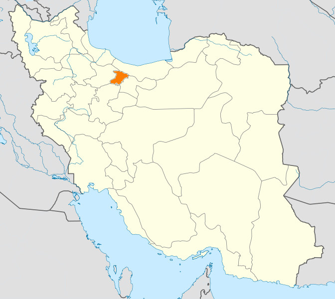
English: Location map of Iran. Equirectangular projection. Strechted by 118.0%. Geographic limits of the map: * N: 40.0° N * S: 24.5° N * W: 43.5° E * E: 64.0° E Made with Natural Earth. Free vector and raster map data @ naturalearthdata.com. |
| چېسلا | (UTC) |
| مەنبە | |
| يازغۇچى |
|
| This is a retouched picture, which means that it has been digitally altered from its original version. Modifications: New map with Alborz province highlighted.. The original can be viewed here: Iran location map.svg:
|
I, the copyright holder of this work, hereby publish it under the following licenses:
This file is licensed under the Creative Commons Attribution-Share Alike 3.0 Unported license.
- سىز ئەركىن:
- بەھىرلەش – to copy, distribute and transmit the work
- ئۆزگەرتىش – ئىجادىي ئەسەر
- تۆۋەندىكى شەرتلەرگە چوقۇم ئەمەل قىلىڭ:
- ئىمزا – You must give appropriate credit, provide a link to the license, and indicate if changes were made. You may do so in any reasonable manner, but not in any way that suggests the licensor endorses you or your use.
- ئوخشاش ئۇسۇلدا بەھىرلەش – If you remix, transform, or build upon the material, you must distribute your contributions under the same or compatible license as the original.

|
Permission is granted to copy, distribute and/or modify this document under the terms of the GNU Free Documentation License, Version 1.2 or any later version published by the Free Software Foundation; with no Invariant Sections, no Front-Cover Texts, and no Back-Cover Texts. A copy of the license is included in the section entitled GNU Free Documentation License. |
You may select the license of your choice.
Original upload log
This image is a derivative work of the following images:
- File:Iran_location_map.svg licensed with Cc-by-sa-3.0, GFDL
- 2010-07-11T20:08:23Z Uwe Dedering 1200x1071 (655114 Bytes) 31. province Alborz
- 2010-02-18T17:44:29Z Uwe Dedering 1200x1071 (721726 Bytes) Bahrain above water, no disputed countries
- 2010-02-18T13:00:48Z Uwe Dedering 1200x1071 (725716 Bytes) {{Information |Description={{en|1=Location map of Iran. Equirectangular projection. Strechted by 118.0%. Geographic limits of the map: * N: 40.0° N * S: 24.5° N * W: 43.5° E * E: 64.0° E Made with Natural Earth. Fre
Uploaded with derivativeFX
ھۆججەت تارىخى
چېسلا/ۋاقىت چېكىلسە ئەينى ۋاقىتتا كۆرۈلگەن ھۆججەتنى كۆرسىتىدۇ.
| چېسلا/ۋاقىت | كىچىك سۈرەت | ئۆلچەم | ئىشلەتكۈچى | ئىزاھات | |
|---|---|---|---|---|---|
| نۆۋەتتىكى | 20:48, 24 يانۋار 2011 | | 672 × 600 (143 KB) | WikiDaisy | {{Information |Description={{en|1=Location map of Iran. Equirectangular projection. Strechted by 118.0%. Geographic limits of the map: * N: 40.0° N * S: 24.5° N * W: 43.5° E * E: 64.0° E Made with Natural Earth. Free vector and raster map data @ |
ھۆججەت ئىشلىتىلىشى
تۆۋەندىكى بەت بۇ ھۆججەتنى ئىشلىتىدۇ:
ئورتاق ھۆججەت ئىشلىتىلىشى
تۆۋەندىكى باشقا ۋىكىلار بۇ ھۆججەتنى ئىشلىتىدۇ:
- ceb.wikipedia.org دىكى ئىشلىتىشى
- hak.wikipedia.org دىكى ئىشلىتىشى
- hi.wikipedia.org دىكى ئىشلىتىشى
- hr.wikipedia.org دىكى ئىشلىتىشى
- mk.wikipedia.org دىكى ئىشلىتىشى
- mr.wikipedia.org دىكى ئىشلىتىشى
- no.wikipedia.org دىكى ئىشلىتىشى
- pa.wikipedia.org دىكى ئىشلىتىشى
- pl.wikipedia.org دىكى ئىشلىتىشى
- pl.wikivoyage.org دىكى ئىشلىتىشى
- ps.wikipedia.org دىكى ئىشلىتىشى
- sco.wikipedia.org دىكى ئىشلىتىشى
- sh.wikipedia.org دىكى ئىشلىتىشى
- sv.wikipedia.org دىكى ئىشلىتىشى
- tr.wikipedia.org دىكى ئىشلىتىشى
- Kerec
- İran'daki yerleşim birimleri listesi
- Elburz (eyalet)
- Kerec şehristanı
- Nezerabad şehristanı
- Savucbulag şehristanı
- Şablon:Elburz Eyaleti
- Nezerabad
- Heştgerd
- Kerec merkezî bahşı
- İştihard şehristanı
- Asara bahşı
- Nezerabad merkezî bahşı
- Tankaman bahşı
- Savucbulag merkezî bahşı
- Çendar bahşı
- Çeharbağ bahşı
- Taligan merkezî bahşı
- Asara
- İştihard
- Taligan
- Germdere
- Kemalşehr
- Mahdeşt
- Meşkindeşt
- Muhammedşehr
- Çeharbağ
- Gülsar
- Kuhsar
- Yeni Heştgerd
- war.wikipedia.org دىكى ئىشلىتىشى
- zh-min-nan.wikipedia.org دىكى ئىشلىتىشى
- zh.wikipedia.org دىكى ئىشلىتىشى