ھۆججەت:NPS white-house-map.pdf

Size of this JPG preview of this PDF file: 386 × 600 پىكسېل. باشقا چوڭلۇقى: 154 × 240 پىكسېل | 309 × 480 پىكسېل | 494 × 768 پىكسېل | 659 × 1,024 پىكسېل | 1,318 × 2,048 پىكسېل | 2,925 × 4,543 پىكسېل.
ئەسلى ھۆججەت (2,925 × 4,543 پىكسېل، ھۆججەت چوڭلۇقى: 373 KB، MIME تىپى: application/pdf)
ئۈزۈندە
| چۈشەندۈرۈش |
English: This President’s Park map shows the entire grounds of the White House, just off the National Mall to the north. |
| چېسلا | |
| مەنبە | U.S. National Park Service (http://npmaps.com/wp-content/uploads/white-house-map.pdf) |
| يازغۇچى | U.S. National Park Service, restoration/cleanup by Matt Holly |
| Other versions |
 |
ئىجازەت
| This image or media file contains material based on a work of a National Park Service employee, created as part of that person's official duties. As a work of the U.S. federal government, such work is in the public domain in the United States. See the NPS website and NPS copyright policy for more information. |
ھۆججەت تارىخى
چېسلا/ۋاقىت چېكىلسە ئەينى ۋاقىتتا كۆرۈلگەن ھۆججەتنى كۆرسىتىدۇ.
| چېسلا/ۋاقىت | كىچىك سۈرەت | ئۆلچەم | ئىشلەتكۈچى | ئىزاھات | |
|---|---|---|---|---|---|
| نۆۋەتتىكى | 01:57, 17 ماي 2017 | 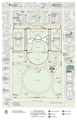 | 2,925 × 4,543 (373 KB) | RKBot | =={{int:filedesc}}== {{Information |description= {{en|1=This President’s Park map shows the entire grounds of the White House, just off the National Mall to the north.}} |date= 2016-11-27 |source= U.S. National Park Service (http://npmaps.com/wp-cont... |
ھۆججەت ئىشلىتىلىشى
تۆۋەندىكى بەت بۇ ھۆججەتنى ئىشلىتىدۇ:
ئورتاق ھۆججەت ئىشلىتىلىشى
تۆۋەندىكى باشقا ۋىكىلار بۇ ھۆججەتنى ئىشلىتىدۇ:
- en.wikipedia.org دىكى ئىشلىتىشى
- es.wikipedia.org دىكى ئىشلىتىشى
- he.wikipedia.org دىكى ئىشلىتىشى